Dürremonitor Deutschland (German Drought Monitor) is a comprehensive daily monitoring system developed by the Helmholtz Centre for Environmental Research (UFZ) that provides real-time, spatially-explicit information about soil moisture conditions and drought status across Germany. The system utilizes the mesoscale hydrological model (mHM) to deliver daily updates on drought conditions at high spatial resolution.
The monitor serves as Germany's primary drought early warning system, offering critical information for agriculture, water management, emergency planning, and climate adaptation, with daily maps showing current drought conditions compared to long-term historical patterns.
Key Features
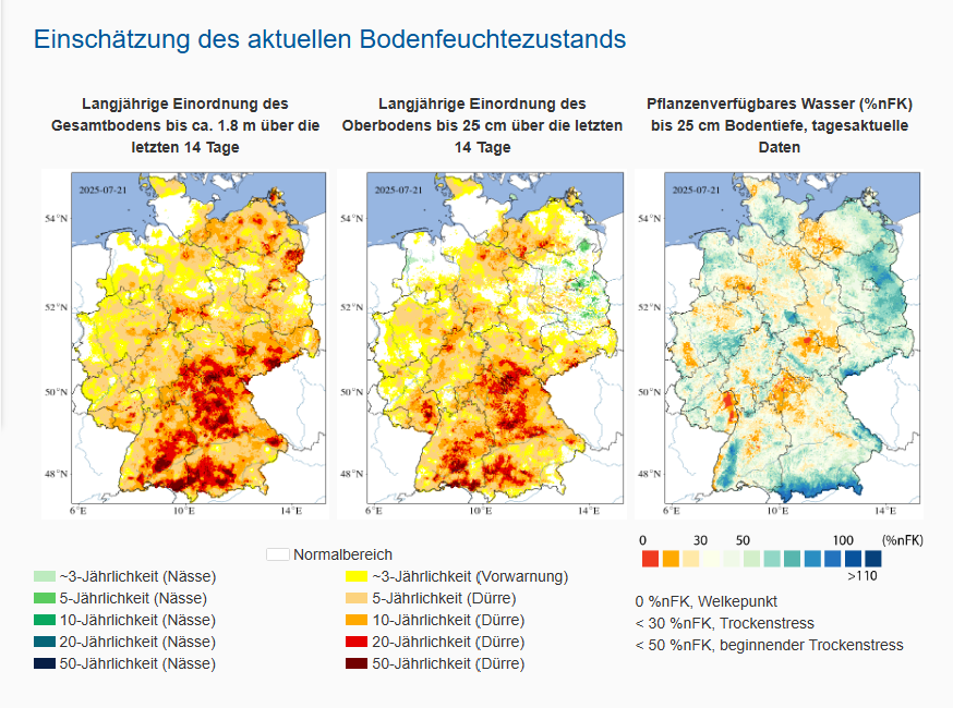
- Daily drought monitoring with high-resolution (1 km) spatial coverage across Germany
- Multi-layer soil analysis tracking both surface soil (0-25 cm) and total soil column (up to 1.8-2 m depth)
- Plant-available water content measurements showing agricultural drought stress levels
- Long-term comparison using statistical analysis against 1974-2023 baseline period
- Animated time series showing drought development over the last 14 days
- State-level maps providing detailed regional drought assessments for each German federal state
Applications
- Agricultural management supporting irrigation planning and crop stress assessment
- Water resource management informing reservoir operations and drought response strategies
- Emergency preparedness enabling early warning for drought-related impacts
- Insurance industry providing data for agricultural and climate risk assessments
- Research and monitoring supporting drought and climate impact studies
- Policy development informing drought adaptation and water management policies
Drought Indicators
- Soil moisture percentiles showing current conditions relative to historical distribution
- Drought severity classes ranging from normal conditions to extreme drought (50-year return periods)
- Plant-available water indicating stress levels for vegetation and crops
- Wet conditions also monitored, showing areas with above-normal soil moisture
- Return period analysis identifying drought frequency (3-year, 5-year, 10-year, 20-year, 50-year events)
Technical Specifications
- mHM hydrological model (mesoscale Hydrologic Model) providing scientific foundation
- Daily data updates ensuring timely information for decision-making
- 1 km spatial resolution offering detailed local-scale drought information
- 14-day rolling average providing stable drought assessments while capturing rapid changes
- Quality-controlled inputs using data from German Weather Service (DWD) and multiple agencies
- Real soil depth modeling based on German soil survey data (BÜK200)
Data Sources and Partnerships
- German Weather Service (DWD) providing daily meteorological data
- European Environment Agency (EEA) contributing environmental datasets
- Federal Institute for Geosciences and Natural Resources (BGR) supplying soil information
- Federal Institute of Hydrology (BfG) providing hydrological data
- NASA and international agencies contributing satellite and global datasets
User Resources
- Interactive web maps with zoom, layer selection, and time navigation capabilities
- Data download options providing access to current and historical drought data
- Photo gallery featuring user-submitted drought impact documentation
- Educational materials explaining drought science and monitoring methodologies
- Regular updates with expert analysis of current drought conditions and impacts
The Dürremonitor Deutschland represents a critical infrastructure for drought monitoring and early warning in Germany, supporting climate adaptation and resilience planning in an increasingly drought-prone climate through scientifically-based, high-resolution monitoring capabilities.