September was all about refinement and power. We shipped features that give you more control over your maps, better tools for data management, and a significantly improved mobile experience. From stunning new basemaps to advanced filtering capabilities, these updates make Atlas more flexible and intuitive than ever.
Here's the full breakdown:
New Features
Five new basemaps
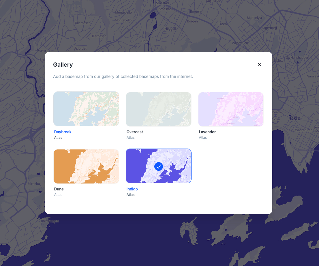
We've expanded your mapping options with five beautifully crafted basemaps: Daybreak, Overcast, Lavender, Dune, and Indigo. Each style offers a unique visual approach to your geospatial data, giving you more creative control over how your maps are presented. The new styles are now available in the basemap gallery with an improved responsive design that adapts seamlessly across different screen sizes.
Enhanced legend management
Reorder and remove specific items from map legends through an intuitive drag-and-drop interface. This replaces the previous all-or-nothing approach with granular control over which legend items are displayed and in what order, making it easier to create clean, focused map presentations.
Save filtered data as new dataset
Save filtered data as a new dataset with a single click. When working with filtered datasets, a "Save as new dataset" button appears that creates a permanent filtered copy using the current filter criteria, making it easier to preserve and share specific data subsets.
Custom mask filter ranges
Configure mask filters with completely customizable range settings, giving you precise control over how data is filtered and displayed. This enhancement addresses the gap issue for travel time analysis and provides much more flexibility in defining filter criteria to match your specific analytical needs.
Enhanced image carousel for feature popups
Feature popups now support multiple images with an elegant carousel interface. When multiple images are attached to a feature, you can navigate through them using intuitive controls. The system intelligently displays dot indicators for up to 5 images and switches to a counter pill for larger collections.
Satellite area of interest (AOI) tool
Added satellite AOI functionality for defining specific areas of interest in satellite imagery analysis, expanding Atlas's remote sensing capabilities.
Smart mobile popup navigation
Mobile users now experience adaptive popup navigation that switches between dot indicators (2-6 items) and a compact navigator (7+ items) based on content volume. The system eliminates unnecessary padding for single popups and provides better accessibility with ARIA labels and keyboard navigation support.
Enhanced layer height control
The layer styling interface now supports more granular height multiplier adjustments with 3 decimal places of precision, allowing for finer control over 3D visualization and elevation scaling. This improvement enables more precise height adjustments for detailed terrain and building visualization.
Improvements
DataTable Experience
- Tabular datasets (those without geodata) now automatically open in DataTable view
- When DataTable is already open, clicking another dataset name immediately switches to show that dataset's table instead of closing the view
- Fixed data table header menu positioning issues in widget views by implementing proper portal-based rendering
Mobile Enhancements
- Mobile interface now includes a fully functional location search drawer
- Enhanced form submission modal with better responsive design
- Improved mobile form experience with better responsive layout that adapts to smaller screens
- Enhanced fullscreen modal display on mobile devices
Project Management
- Enhanced project search experience with clear feedback when no results are found
- "Showing results for..." indicators when search returns results
- Subscription upgrade notifications now appear when customers successfully upgrade their plans
- Clearable sorting for feature lists with a "No sorting" option to return to default order
Interface Polish
- Widget overflow issues in island mode fixed - widgets now display their full content properly
- Improved collection selection by making the entire list item clickable
- Reduced default border radius on modals for a cleaner appearance
- Fixed inconsistent padding around images in map popups
- Enhanced zoom behavior in the georeferencing modal for consistency
- Improved color palette functionality where increasing step counts properly updates color pickers
- Consistent warning button styling throughout the interface
- Enhanced layer name truncation using CSS-based ellipsis instead of character limits
Navigation & Interaction
- Added tab/shift-tab keyboard navigation support for location search
- Added escape key functionality to filter components for quicker dismissal
- Fixed search results from shifting position when hovering over them
- Improved drag-and-drop functionality in field lists
- Enhanced side menu opacity during drag operations for better visual feedback
Data & Forms
- Form data safety: Column editor now asks for confirmation before closing with unsaved changes
- Better error messages and toast notifications for subscription plan issues
- Fixed form submission buttons being permanently disabled in certain workflows
- Improved multi-select component overflow issues in forms with proper text truncation
- Enhanced dataset label display in form submissions to show full names instead of IDs
Fixes
- Corrected marker positioning in the georeferencing tool so the pointed tip accurately indicates the selected coordinates
- Resolved visual glitches in feature input components when features were selected
- Fixed column value select components for filters that were becoming unusable during search
- Corrected Mapillary instruction text to accurately describe the orange marker color
- Fixed popup settings not displaying properly in certain contexts
- Resolved PostgreSQL icon display issue caused by incorrect filename casing
- Fixed app crashes when editing travel time nodes in workflows
- Prevented chat box from always closing on escape key when users have typed content
- Fixed ghost geometries remaining on map after layer deletion - selected features are now properly cleared when their source layer is removed
- Resolved toolbar tooltip positioning and improved display timing
- Fixed dropdown menus in legend panels to prevent accidental dragging
- Enhanced upload file buttons with improved visual design
- Added better error handling for georeferencing with invalid bounds
- Fixed embed code generation to properly validate project IDs before creating shareable links
- Resolved field type icon display issues in data type selectors
- Fixed user variable selection components appearing behind modal overlays
- Fixed plus button positioning on guest profile fields in the right panel
- Resolved modal height calculation issues to properly adjust for content changes
- Fixed branding state loading issues that could cause infinite loading states
- Corrected text color application to respect configured theme colors
- Improved folder name display with line breaks for deeply nested structures
- Enhanced draw menu width consistency to prevent layout shifts during selection
- Fixed user variables empty state alignment
- Prevented project owner removal and permission changes to maintain security
Feedback
Improving Atlas is our top priority. We're fully focused on making things faster, smoother, and more reliable — both in the small details and the bigger workflows. If you've hit a bug, felt stuck, or thought "this could be better"… we want to hear it.
We've set up a dedicated Feedback portal where you can report issues, suggest improvements, or request features — all in one place. It goes straight to the engineering team. Every submission helps us make Atlas better for everyone.