WWF Biodiversity Risk Filter is a free online business tool that enables companies and financial institutions to assess and act on biodiversity-related risks through comprehensive screening and analysis capabilities.
Part of the WWF Risk Filter Suite, this tool provides corporate and portfolio-level screening to help organizations identify biodiversity risks and prioritize action across their operations, supply chains, and investments for enhanced business resilience.
Whether you're working on nature-related financial disclosure, supply chain risk management, or sustainability strategy, the WWF Biodiversity Risk Filter provides essential intelligence for understanding and managing biodiversity dependencies and impacts.
1. Free Biodiversity Risk Assessment
The WWF Biodiversity Risk Filter provides completely free access to sophisticated risk analysis:
- No licensing fees or subscription costs
- Corporate and portfolio-level screening capabilities
- Upload and manage data in secure online platform
- Science-based risk indicators and methodologies
- TNFD, CSRD, and GRI reporting alignment
2. Four-Module Assessment Framework
The tool offers a structured approach to biodiversity risk assessment:
INFORM Module:
- Industry-specific biodiversity dependencies and impacts
- Sector analysis for understanding material risks
- Direct impacts and dependencies focus
- Weighted risk factors by industry type
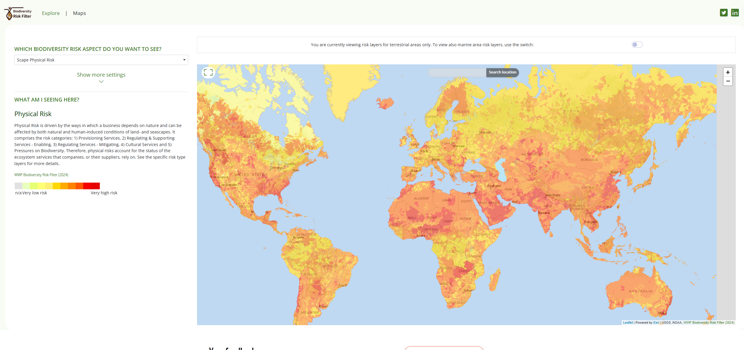
EXPLORE Module:
- Interactive maps for physical and reputational risks
- 33 biodiversity indicators globally
- Spatial risk visualization and analysis
- Country and regional risk profiles
ASSESS Module:
- Operations, supply chain, and investment risk analysis
- Location-specific risk scoring
- Portfolio-level risk aggregation
- Custom reporting and data export
ACT Module (Coming Soon):
- Risk mitigation strategies and guidance
- Resilience enhancement recommendations
- Action planning tools and resources
3. Biodiversity Risk Types
The filter assesses two primary risk categories:
Physical Risk:
- Ecosystem service decline impacts on operations
- Biodiversity loss affecting business dependencies
- Natural capital degradation risks
- Location-specific vulnerability assessment
Reputational Risk:
- Stakeholder perception and community concerns
- Media scrutiny and public attention
- Protected area proximity risks
- Conflict and governance factors
4. State of Biodiversity Health Assessment
The tool evaluates biodiversity health using comprehensive indicators:
- Ecosystem diversity and intactness
- Species diversity and abundance
- Ecosystem services provision
- Biodiversity pressures and threats
- Conservation status and protection levels
5. Reporting and Disclosure Support
The WWF Biodiversity Risk Filter supports major reporting frameworks:
- TNFD (Taskforce on Nature-related Financial Disclosures) reporting
- CSRD ESRS (European Sustainability Reporting Standards)
- GRI biodiversity indicators
- SBTN (Science Based Targets for Nature) target setting
- CDP (Carbon Disclosure Project) water and forests
Getting Started with WWF Biodiversity Risk Filter
- Register for free at riskfilter.org
- Upload your data to the Portfolio Manager
- Explore industry impacts in the Inform module
- Analyze spatial risks using the Explore module
- Assess portfolio risks in the Assess module
- Generate reports for disclosure and decision-making
Use Cases
- Nature-Related Financial Disclosure: Support TNFD and CSRD reporting
- Supply Chain Risk Management: Identify biodiversity hotspots in sourcing
- Investment Screening: Assess biodiversity risks in portfolios
- ESG Strategy Development: Integrate biodiversity into sustainability planning
- Due Diligence: Evaluate biodiversity risks in M&A transactions
- Stakeholder Engagement: Communicate biodiversity impacts and dependencies
The WWF Biodiversity Risk Filter empowers organizations to understand their relationship with nature and take meaningful action to reduce biodiversity risks while contributing to a more sustainable future.