
When we started building Atlas, we wanted to make it simple to work with maps and spatial data — right from your browser.
As more people joined the platform, users would often ask us if they could use Atlas for collecting data from people who don't use Atlas.
It was a fair point.
If you wanted feedback from a community, or field data from volunteers, you had to juggle Google Forms, spreadsheets, location pins, and manual uploads.
It didn’t make sense.
So we built something new.
What is Forms?
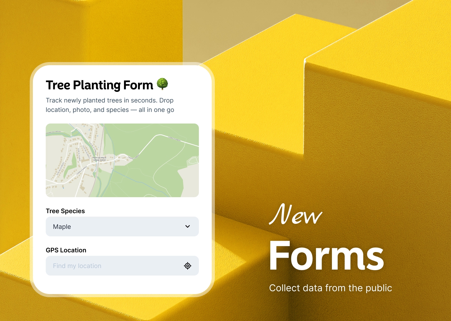
Forms is a way to collect geo-tagged submissions from anyone — with a simple public link.
You create a form inside your Atlas project, customize the fields, and share it.
People can then fill it out on any device. They don’t need an account.
Each submission is automatically geo-tagged and appears right in your map.
Who is this for?
Forms is for anyone who needs location-based data from the public.
Use it to collect:
- Community feedback
- Field reports
- Survey responses
- Incident reports
- Event check-ins
You don’t need to be technical. No coding. No setup headaches.
Just create, share, and watch the data come in.
A Better Way to Collect Spatial Data
Having people drop pins on Google Maps and then emailing you the coordinates?
That’s over.
Forms keeps everything in one place:
- A single project
- A single source of truth
- Real-time updates
You can even build multiple forms for different use cases—all connected to your map.
Key Features
No-Code Builder
Use the built-in editor to create a form that fits your needs.
Add fields like text inputs, dropdowns, photo uploads, and more.
Public Link Sharing
Once your form is ready, copy the link and share it anywhere.
Email. Social media. QR code on a poster.
No login required for submissions.
Auto Geo-Tagging
Every submission includes location data.
Users can pick a location on the map or use GPS if they’re on mobile.
That means you get accurate, mappable data—every time.
Live Map Integration
Submissions go straight to your Atlas project.
They show up on your map in real time, ready for review and action.
You don’t have to export or import anything.
Example Use Cases
Local Governments
Collect pothole reports, sidewalk damage, or graffiti sightings from citizens.
All with location, photos, and notes.
NGOs and Field Teams
Track environmental data, water access, or damage assessments from volunteers.
Even offline—just sync later.
Event Organizers
Let vendors or attendees submit booth info, feedback, or incidents during events.
Everything shows up on one map.
Built for Teams
Forms makes it easy for anyone on your team to contribute.
Create forms for specific teams or roles.
You can also filter submissions, leave comments, and manage responses—directly inside Atlas.
Safe and Secure
You control who sees the form.
You can turn off submissions anytime or require approval before data goes live.
All data stays in your Atlas account — no third-party tools.
Get Started with Forms
Forms is now live and available in every Atlas account.
To try it out:
- Open your Atlas project
- Navigate to Forms in the side menu
- Click "New Form"
- Select a dataset
- Adjust fields
- Share the link
- Start collecting geo-tagged submissions
It’s that easy.
This is just the beginning. We can’t wait to see how you use Forms.


