Latitude and Longitude
Latitude and longitude are the most fundamental concepts for mapping and understanding locations on Earth. They are coordinates used to pinpoint any spot on the planet, enabling accurate navigation, analysis, and communication of locations.
What are Latitude and Longitude?
Latitude and longitude form a grid system that covers the Earth. Together, they define coordinates for any point on the planet's surface.
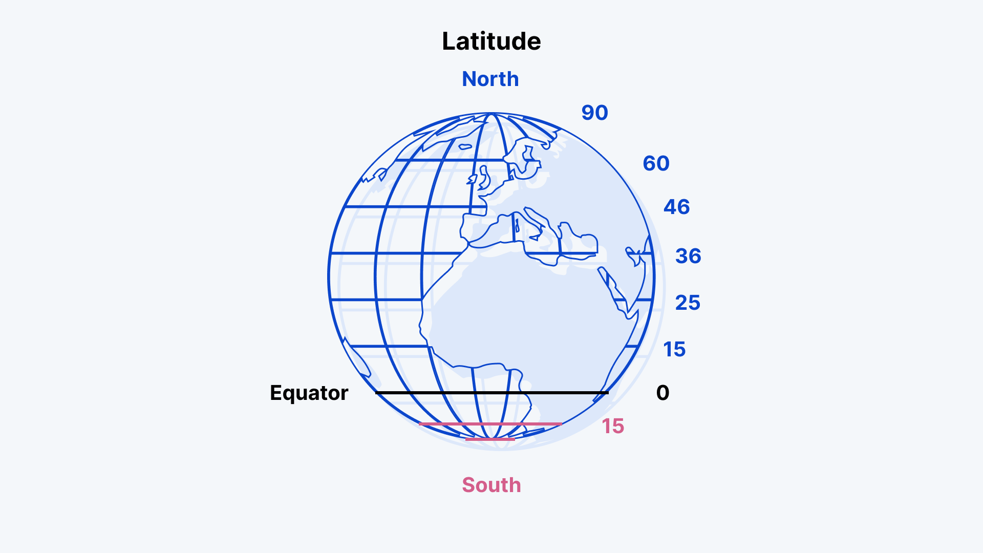
- Latitude measures how far north or south a point is from the equator.
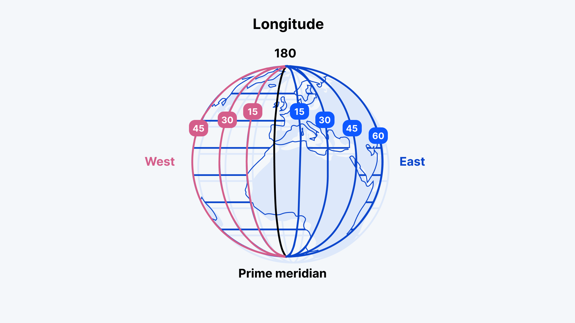
- Longitude measures how far east or west a point is from the Prime Meridian.
These coordinates are written as a pair of numbers: latitude first, then longitude. For example, the coordinates of the Eiffel Tower in Paris are 48.8584° N, 2.2945° E.
Latitude: The Horizontal Lines
Latitudes are the horizontal lines that run across the Earth.
- The equator is at 0° latitude and divides the Earth into the Northern Hemisphere and the Southern Hemisphere.
- Latitude increases as you move north or south from the equator:
- 90° North (North Pole)
- 90° South (South Pole)

Key Lines of Latitude
- Equator (0°)
- Tropic of Cancer (23.5° North)
- Tropic of Capricorn (23.5° South)
- Arctic Circle (66.5° North)
- Antarctic Circle (66.5° South)
The tropics define the area of Earth that experiences the most direct sunlight. The Arctic and Antarctic Circles mark the boundaries where polar regions experience periods of continuous daylight or darkness.
Longitude: The Vertical Lines
Longitudes are the vertical lines that run from the North Pole to the South Pole.
- The Prime Meridian is at 0° longitude and passes through Greenwich, England. It divides the Earth into the Eastern Hemisphere and the Western Hemisphere.
- Longitude increases as you move east or west:
- Up to 180° East or 180° West, which meet on the opposite side of the globe (International Date Line).

How Latitude and Longitude Work Together
When you combine latitude and longitude, you get a coordinate system that uniquely identifies any location on Earth.
Coordinates are typically written in degrees (°), minutes ('), and seconds (''):
- Latitude: Always comes first (North or South)
- Longitude: Follows (East or West)
For example:
- 48° 51' 30" N, 2° 17' 40" E pinpoints the Eiffel Tower.
The Role of Latitude and Longitude in GIS
Geographic Information Systems (GIS) rely on latitude and longitude for mapping and analyzing spatial data. Coordinates help GIS software like Atlas visualize, analyze, and share location-based insights.
Real-World Uses:
- Navigation: Latitude and longitude power GPS systems for directions.
- Mapping: GIS tools use coordinates to display data accurately on maps.
- Site Selection: Businesses use coordinates to identify suitable locations.
- Weather Monitoring: Meteorologists track storms using latitude and longitude.
- Emergency Response: Rescue teams rely on precise coordinates for locating people or incidents.
Latitude and Longitude in Atlas
With a platform like Atlas, you can easily upload and visualize location data using latitude and longitude coordinates. Atlas makes it simple to:
- Import data files (e.g., CSV with latitude and longitude columns)
- Plot locations on interactive maps
- Share maps with teams for collaboration
For example, you could map all your store locations by uploading a spreadsheet with their latitude and longitude.
Why Latitude and Longitude Matter
Latitude and longitude are the foundation of location-based analysis. Whether you're creating a simple map or performing complex geospatial analysis, these coordinates ensure accuracy.
From global businesses to environmental researchers, anyone working with geographic data relies on latitude and longitude to understand, analyze, and communicate location-based insights.
So next time you use a map or a navigation tool, remember the power of latitude and longitude working behind the scenes.


