When working with geographic information systems (GIS), understanding the differences between DEM, DSM, and DTM is crucial.
These three terms are often used interchangeably but refer to distinct types of data that represent the Earth's surface in different ways. This article will break down what each of these terms means and how they are used in GIS applications.
What is DEM?
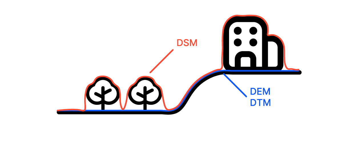
A Digital Elevation Model (DEM) represents the bare earth's surface, stripped of any objects like trees, buildings, or other structures. It captures the ground's elevation and is widely used in a variety of applications, from environmental studies to urban planning.
DEM data is usually generated using remote sensing techniques such as LiDAR, photogrammetry, or radar. It provides a 3D representation of the terrain's surface and is often used as a base layer for many GIS projects.
Key points to remember about DEM:
- Focuses on ground elevation: It doesn't include buildings, vegetation, or other above-ground features.
- Used in various analyses: DEMs are essential for tasks like flood modeling, land use planning, and slope analysis.
- Resolution matters: The accuracy of a DEM depends on its resolution. High-resolution DEMs provide more detailed elevation data, but they require more storage and processing power.
What is DSM?
A Digital Surface Model (DSM) captures not only the bare ground but also the natural and man-made features on the surface. This includes buildings, trees, and any other objects that protrude from the earth's surface. In other words, a DSM shows the elevation of the topmost surface.
DSM data is particularly useful in urban planning, forestry, and telecommunications because it gives a clear picture of the actual landscape, including all structures and vegetation.
Key points to remember about DSM:
- Includes surface features: Unlike DEMs, DSMs account for buildings, trees, and other structures.
- Useful in specific applications: DSMs are crucial in projects where the height of structures and vegetation affects the analysis, such as line-of-sight studies for telecommunications.
- Can be created from similar data sources: Like DEMs, DSMs can be generated from LiDAR, photogrammetry, or radar data. However, they often require additional processing to distinguish between ground and non-ground features.
What is DTM?
A Digital Terrain Model (DTM) is a refined version of a DEM. It not only represents the bare earth but also includes features such as breaklines, ridges, and valleys. DTMs often involve additional data processing to provide a more detailed and accurate representation of the terrain.
While DEMs are often used for broader applications, DTMs are preferred in engineering projects where a detailed understanding of the terrain is crucial, such as in road design, drainage planning, and construction.
Key points to remember about DTM:
- Enhanced terrain detail: DTMs include additional features like breaklines, which help in understanding the terrain better.
- Preferred for engineering projects: DTMs are used in applications where a high level of detail about the terrain is necessary.
- Derived from DEMs: A DTM can be seen as an enhanced DEM, often created by adding extra data to an existing DEM.
Comparing DEM, DSM, and DTM
While DEM, DSM, and DTM might seem similar, they serve different purposes and are used in different contexts. Understanding their differences helps in choosing the right model for your GIS project.
-
Elevation Data:
- DEM focuses on the bare ground.
- DSM includes everything on the surface.
- DTM refines the ground data with additional terrain features.
-
Applications:
- DEMs are used for basic terrain analysis, flood modeling, and other applications where the ground surface is the primary concern.
- DSMs are essential in urban planning, forestry, and any project that needs to account for surface features.
- DTMs are preferred in engineering and construction projects where detailed terrain information is critical.
-
Data Sources and Processing:
- All three models can be created using similar data sources like LiDAR, photogrammetry, or radar.
- DSMs and DTMs often require additional processing to distinguish between the ground and other features or to add more detail to the terrain.
Choosing the Right Model
Choosing between a DEM, DSM, and DTM depends on the specific needs of your project.
-
If you need a simple elevation model for large-scale terrain analysis, a DEM is usually sufficient. It provides a clear picture of the ground surface without complicating factors like buildings or vegetation.
-
If your project involves urban areas, forests, or any place where surface features are important, a DSM is likely the better choice. It allows you to account for all the structures and vegetation that might affect your analysis.
-
For projects that require detailed terrain information, such as engineering or construction, a DTM is the best option. It provides the most accurate representation of the terrain, including important features like ridges and valleys.
Common Uses in GIS
In the world of GIS, these models are indispensable tools for a variety of applications.
- DEM: Widely used in flood risk assessment, topographic mapping, and any analysis where the shape of the earth’s surface is the focus.
- DSM: Crucial for urban development, telecommunications (like planning antenna placement), and forest canopy studies.
- DTM: Essential for any project that requires an accurate terrain model, such as road design, landscape planning, and hydrological modeling.


